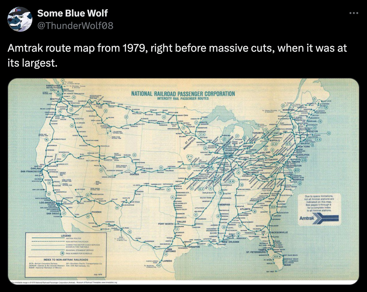
Flying Squid@lemmy.world to Fuck Cars@lemmy.worldEnglish · edit-23 months ago1979lemmy.worldimagemessage-square43fedilinkarrow-up11arrow-down10file-text
arrow-up11arrow-down1image1979lemmy.worldFlying Squid@lemmy.world to Fuck Cars@lemmy.worldEnglish · edit-23 months agomessage-square43fedilinkfile-text
minus-squareBeacon@fedia.iolinkfedilinkarrow-up0·3 months agoWithout an “after” pic showing the map as it is now, this isn’t informative for most people
minus-squareFlying Squid@lemmy.worldOPlinkfedilinkEnglisharrow-up0·3 months ago I’ll edit and put it in the body too. Good call.
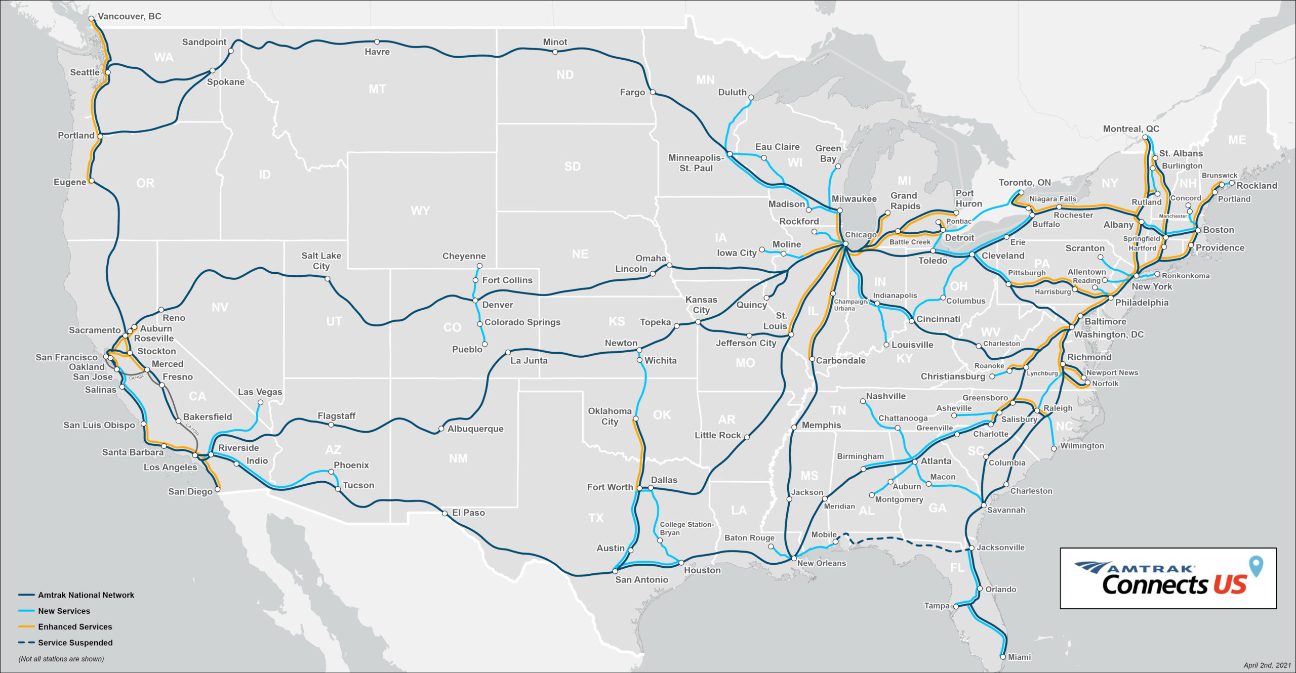
minus-squarenexguy@lemmy.worldlinkfedilinkEnglisharrow-up0·edit-23 months agoThis map doesn’t show all the stations. Here is the actual current map From https://www.amtrak.com/content/dam/projects/dotcom/english/public/documents/Maps/Amtrak-System-Map-1018.pdf
minus-squareOBJECTION!@lemmy.mllinkfedilinkEnglisharrow-up0·edit-23 months agoImportant to note the key in the bottom left. The green lines aren’t trains, they’re generally bus routes that Amtrak coordinates with.
minus-squareFlying Squid@lemmy.worldOPlinkfedilinkEnglisharrow-up0·3 months agoBlame Amtrak. I got the image from their website.
minus-squarekerrigan778@lemmy.worldlinkfedilinkEnglisharrow-up0·3 months agoThat map is on the Amtrak website in an article highlighting areas of planned new development. https://media.amtrak.com/amtrak-connects-us/
minus-squareFlying Squid@lemmy.worldOPlinkfedilinkEnglisharrow-up0·3 months agoAh, my mistake. Thanks.
minus-squaredrolex@sopuli.xyzlinkfedilinkEnglisharrow-up0·3 months agoThe European mind cannot comprehend this simple trick!
minus-squareunexposedhazard@discuss.tchncs.delinkfedilinkEnglisharrow-up0·3 months agoSo the grid is basically the same but most of the stations are gone.
minus-squareOofnik@kbin.earthlinkfedilinkarrow-up0·3 months agoI’m not sure why the current map doesn’t show them, but no, the stations are not gone. I ride the Amtrak from Chicago far out west quite often, it still stops in all of the places that the old map says.
minus-squareccunning@lemmy.worldlinkfedilinkEnglisharrow-up0·3 months agoThe “after” pic isn’t showing all the stations.
minus-squareBlackout@fedia.iolinkfedilinkarrow-up0·3 months agoThe other difference is some routes get 2 trains a day and it probably cost $5k to go cross country
minus-squareknexcar@lemmy.worldlinkfedilinkEnglisharrow-up0·3 months ago2 trains a day would be an improvement for many routes, a lot are 1 train a day or 3 trains a week.
minus-squareNouveau_Burnswick@lemmy.worldlinkfedilinkEnglisharrow-up0·3 months agoNice, Nova Scotia exists after 1979.


Without an “after” pic showing the map as it is now, this isn’t informative for most people
I’ll edit and put it in the body too. Good call.
This map doesn’t show all the stations.
Here is the actual current map
From
https://www.amtrak.com/content/dam/projects/dotcom/english/public/documents/Maps/Amtrak-System-Map-1018.pdf
Important to note the key in the bottom left. The green lines aren’t trains, they’re generally bus routes that Amtrak coordinates with.
Blame Amtrak. I got the image from their website.
That map is on the Amtrak website in an article highlighting areas of planned new development. https://media.amtrak.com/amtrak-connects-us/
Ah, my mistake. Thanks.
The European mind cannot comprehend this simple trick!
So the grid is basically the same but most of the stations are gone.
I’m not sure why the current map doesn’t show them, but no, the stations are not gone. I ride the Amtrak from Chicago far out west quite often, it still stops in all of the places that the old map says.
The “after” pic isn’t showing all the stations.
The other difference is some routes get 2 trains a day and it probably cost $5k to go cross country
2 trains a day would be an improvement for many routes, a lot are 1 train a day or 3 trains a week.
Nice, Nova Scotia exists after 1979.